|
STUDIO/AGENTS: The
Foundation will
be working on a draft script for Treasure Island in 2023.
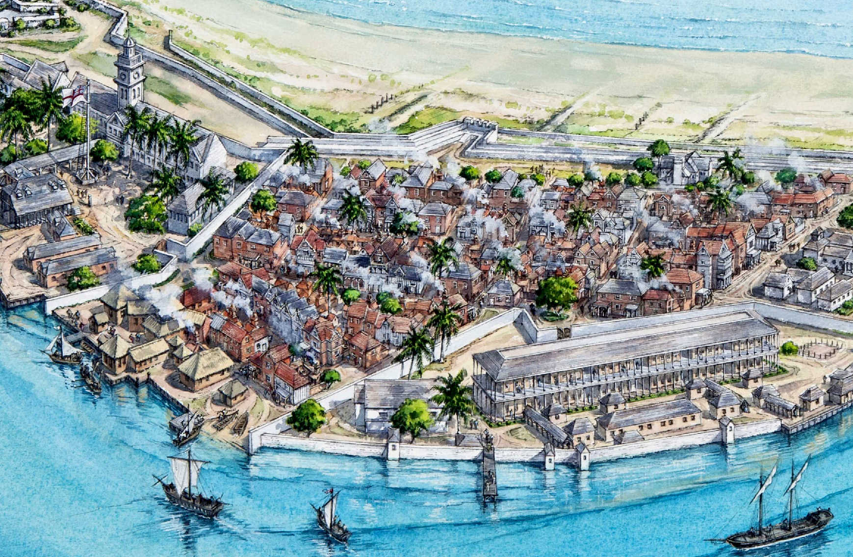
Port
Royal was established by the Spanish in 1518. On June 7, 1692, a massive
earthquake followed by a tsunami killed 2,000 people and submerged the city
of Port Royal in Jamaica. Once called the “wickedest city on earth,”
Port Royal was home to real-life pirates
of the Caribbean,
and the city’s sinking was deemed an act of God. But that did not stop the
pirates,
who just moved farther up the coast.
Today it is deemed to be one of the
best-preserved underwater cites in the world, with only a few items having
been removed and placed into various museums across Jamaica. The submerged
city is a UNESCO
World
Heritage Site contender. You can scuba
dive to the sunken city but need special permission from the authorities to
enter Inner
Space.
Edmund
Heath, survivor and eyewitness to the devastating 1692 earthquake wrote
these words in a letter from the safety of a ship moored in the city’s
harbor, overlooking the ruins of his city. Port Royal, once called “the
most wicked and sinful city in the world” was famous the world over for
its booze - the blackout-inducing Kill Devil Rum, its pirates, and its sex
workers. Needless to say, when the city was nearly destroyed, there were
some parties that saw it as a convenient solution to an ugly problem.
The English and their pirate friends were relatively new to the area.
Jamaica had been held by the Spanish since Columbus first declared it “the
fairest island eyes have beheld” in 1494. Lacking gold or other obvious
exploitable wealth, the Spanish held it but did not focus much energy there.
It came under English power in 1655, after Cromwell sent English raiders to
invade and capture the Spanish stronghold at Hispaniola (now Haiti and
Dominican Republic, then the center of Spanish trade in the Caribbean).
Cromwell’s men failed spectacularly at taking Hispaniola and turned to
Jamaica as a second choice, better-than-nothing option.
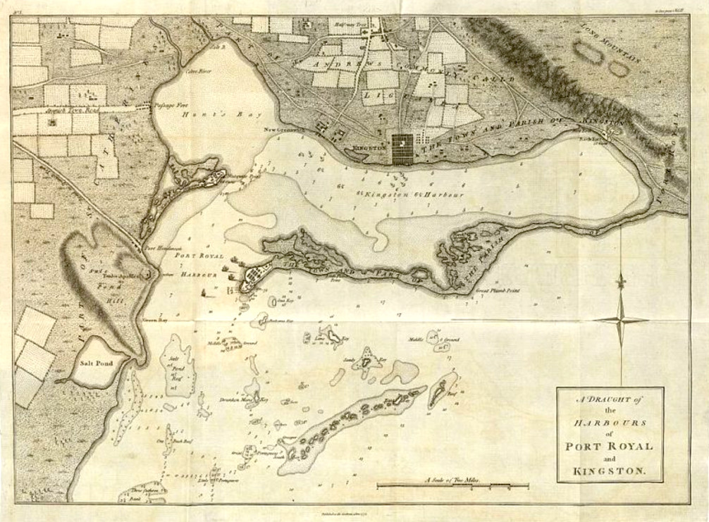
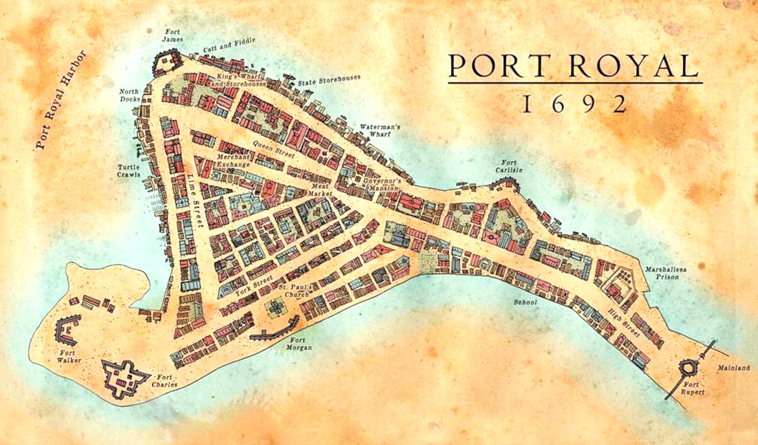
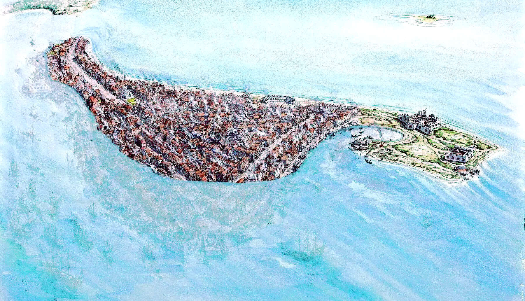
Map
of Port Royal and Kingston
In
1675 the notorious pirate Henry
Morgan became the Lieutenant Governor. In fact, Morgan began to crack
down on overt piracy as the grand era of privateering he had been part of
began to enter its waning phase. He died just four years before the
earthquake struck and was buried in the Palisadoes
cemetery.
On the morning of June 7, 1692, a massive earthquake estimated at a 7.5
magnitude hit the island. The city, largely built over sand, suffered
instantly from liquifaction, with buildings, roads, and citizens sucked into
the ground. Geysers erupted from the earth, buildings collapsed, and finally
the city was hit by tsunami waves, dragging what had not been destroyed out
to sea. In the end, some 33 acres of the city disappeared under water, four
of the five forts were destroyed or submerged, and 2000 people were killed.
The cemetery where Captain Morgan was buried slipped into the sea, its
bodies floating up to mix with the freshly dead.
In 1951, what was left of Port Royal was hit by Hurricane Charlie,
destroying more property and leaving only a few of the original buildings
standing.
Today most of the remains of the 17th century city lie under up to 40 feet
of water. Up until the 1900s visitors reported on the city still visible
below the waves and the eerie sensation of floating over the rooftops. Since
the 1950s, divers have been exploring and cataloging the submerged city. In
1959, Edwin Link discovered the most famous artifact: a pocket watch dated
1686, stopped at exactly 11:43.
More recently the Nautical Archaeology Program at Texas A&M University
and the Jamaica National Heritage Trust conducted underwater archaeological
examinations, ending in 1990. Their explorations have brought to light
artifacts of 17th century life rarely seen. Because of the nature of the
disaster, which left many buildings intact and more or less undisturbed, it
has been compared to Pompeii for its archaeological wonders and was a
designated National Heritage Site in 1999.
Special access from the government is required to dive in the restricted
Port Royal ruins area, but many of the items recovered over the years can be
seen at the Museums of History and Ethnography at the Institute of Jamaica
in Kingston.
CRACK
DOWN ON PIRACY
Port Royal’s attitudes toward piracy shifted with the political tides. When England and Spain were at odds, piracy was lauded, but crackdowns did occur. During one such time in the 1670s (somewhat hypocritically supported by Henry Morgan), those charged formally with piracy were executed on Gallows Point in Port Royal.
In the early 18th century, Jamaica's new governor Nicholas Lawes brought in the English Navy to hunt down pirates operating in Port Royal. Local support for piracy began to wane after the capture and execution of several notorious pirates and their crews, including
Calico Jack Rackham,
Anne
Bonny, Mary
Read, and Charles
Vane.
Rackham, Bonny, and Read were captured in 1720. Rackham and male members of his crew were executed at Gallows Point, but the women’s lives were spared because both were pregnant. Read died in prison (some say during childbirth), but Bonny’s ultimate fate is unknown.
After his conviction, Vane was hanged in 1721. To deter pirates, both the corpses of Rackham and Vane were publicly
displayed - hung from gibbets near the entrance to Port Royal Harbour - as a warning to
passers by and locals about what kind of fate awaited pirate captains and crews who got caught.
This is famously portrayed in the Pirates
of the Caribbean, Disney
franchise.
LOST
CITIES
ATLANTIS
- MEDITERRANEAN SEA
ATLIT-YAM
- ISRAEL
BAIA
- ITALY
DWARKA
- INDIA
PAVLOPETRI
- GREECE
PHANAGORIA
- BLACK SEA
PORT
ROYAL - JAMAICA
RUNGHOLT
- DENMARK
THONIS-HERACLEION
AND ALEXANDRIA - EGYPT
YONAGUNI
JIMA - JAPAN
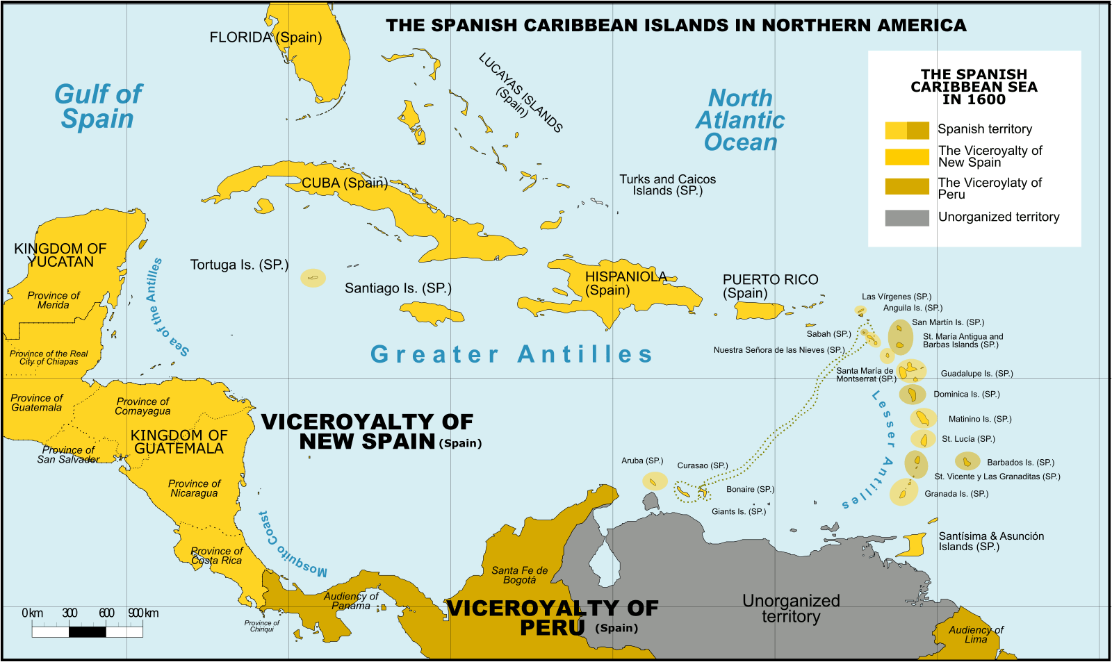
Spanish Caribbean Islands 1600 Spanish Overseas territories Northern America Turks and Caicos Islands (1492-1516, 1516-1678) * Islas Turcas y Caicos The Bahamas (1492-1516, 1516-1648) *Islas Lucayas Bermuda (1503-1516, 1516-1609) *Carabela/Isla de los Diablos Greater Antilles Cuba (1492-1762, 1763-1898) *Juana Cayman Islands (UK) (1503-1670) *Islas de las Tortugas La Española/Hispanola (1492-1795, 1801-1822) Dominican Republic (1492-1795, 1801-1822, 1861-1863) *Santo Domingo Haiti (1492-1793) *Santa María Jamaica (1492-1655) *Isla Santiago Puerto Rico (US) (1493-1898) *San Juan Bautista Lesser Antilles Leeward Islands: Virgin Islands (1493-1587) *Islas Once Mil Vírgenes / Islas Vírgenes St. Thomas (US) (1493-1587) St. John (US) (1493-1587) St. Croix (US) (1493-1587) Water Island (US) (1493-1587) British Virgin Islands (UK) (1493-1648) *Islas Once Mil Vírgenes / Islas Vírgenes Tortola (UK) (1493-1648) Virgin Gorda (UK) (1493-1672) Anegada (UK) (1493-1672) Jost Van Dyke (UK) (1493-1672) Anguilla (UK) (1500-1631, 1631-1650) *Isla de la Anguila Saint Martin/Sint Maarten (France/Neth.) (1493-1631) *San Martín Saint-Barthélemy (Fr.) (1493-1648) *San Bartolomeo Saba (Neth.) (1493-1640) *Saba/San Cristóbal Sint Eustatius (Neth.) (1493-1640) *San Eustaquio St. Kitts and Nevis (1493-1628) *Nuestra Señora de las Nieves Saint Kitts (1493-1628) *San Cristóbal Nevis (1493-1628) *Nieves Antigua and Barbuda Barbuda (1493-1628) *Santa Dulcina Antigua (1493-1632) *Santa María de la Antigua Redonda (1493-1632) *Santa María la Redonda Montserrat (UK) (1493-1632) *Santa María de Monstserrat Guadeloupe (Fr.) (1493-1631) *Santa Guadalupe Windward Islands: Dominica (1493-1635) *Domingo Martinique (Fr.) (1502-1635) *Martinino Saint Lucia (St. Lucia) (1502-1660) *Santa Lucía Barbados (1492-1620) *Los Barbados/El Barbudo St. Vincent and the Grenadines (1498-1627) *San Vicente Saint Vincent the Grenadines Grenada (1498-1650) *Concepción Carriacou & Petite Martinique (Grenada) Trinidad & Tobago (1498-1628) *Santísima e Asunción Aruba (Neth.) (1499-1648) *Aruba/Oroba Curaçao (Neth.) (1499-1634) *Curasao/Isla de los Gigantes Bonaire (Neth.) (1499-1635) * Bonaire/Buon Aire Viceroyalty of New Granada Los Roques Archipelago (Ven) La Orchila (Ven) La Tortuga (Ven) La Blanquilla (Ven) Margarita Island (Ven) Coche (Ven) Cubagua (Ven) Other islands (Ven) *Founded Spanish names
CARIBBEAN ISLANDS - WEST INDIES
The region, situated largely on the Caribbean Plate, has more than 700 islands, islets, reefs and cays (see the list of Caribbean islands). Three island arcs delineate the eastern and northern edges of the
Caribbean
Sea: The Greater Antilles to the north, and the Lesser Antilles and Leeward Antilles to the south and east. Together with the nearby Lucayan Archipelago, these island arcs make up the West Indies.
The Bahamas and the Turks and Caicos Islands are sometimes considered to be a part of the Caribbean, even though they are neither within the Caribbean Sea nor on its border. However, The Bahamas is a full member state of the Caribbean Community and the Turks and Caicos Islands are an associate member. Belize, Guyana, and Suriname are also considered part of the Caribbean despite being mainland countries and they are full member states of the Caribbean Community and the Association of Caribbean States. Several regions of mainland North and South America are also often seen as part of the Caribbean because of their political and cultural ties with the region. These include Belize, the Caribbean region of Colombia, the Venezuelan Caribbean, Quintana Roo in Mexico (consisting of Cozumel and the Caribbean coast of the Yucatán Peninsula), and The Guianas (Guyana, Suriname, French Guiana, Guayana Region in Venezuela, and Amapá in Brazil).
The islands of the Caribbean (the West Indies) are often regarded as a subregion of North America, though sometimes they are included in Middle America or then left as a subregion of their own and are organized into 30 territories including sovereign states, overseas departments, and dependencies. From 15 December 1954, to 10 October 2010, there was a country known as the Netherlands Antilles composed of five states, all of which were Dutch dependencies. From 3 January 1958, to 31 May 1962, there was also a political union called the West Indies Federation composed of ten English-speaking Caribbean territories, all of which were then British dependencies.
These islands include active volcanoes, low-lying atolls, raised limestone islands, and large fragments of continental crust containing tall mountains and insular rivers. Each of the three archipelagos of the West Indies has a unique origin and geologic composition.
GREATER ANTILLES
The Greater Antilles is geologically the oldest of the three archipelagos and includes both the largest islands (Cuba,
Jamaica, Hispaniola, and
Puerto
Rico) and the tallest mountains (Pico Duarte, Blue Mountain, Pic la Selle, Pico Turquino) in the Caribbean. The islands of the Greater Antilles are composed of strata of different geological ages including Precambrian fragmented remains of the North American Plate (older than 541 million years), Jurassic aged limestone (201.3-145 million years ago), as well as island arc deposits and oceanic crust from the Cretaceous (145-66 million years ago).
The Greater Antilles originated near the Isthmian region of present day Central America in the Late Cretaceous (commonly referred to as the Proto-Antilles), then drifted eastward arriving in their current location when colliding with the Bahama Platform of the North American Plate ca. 56 million years ago in the late Paleocene. This collision caused subduction and volcanism in the Proto-Antillean area and likely resulted in continental uplift of the Bahama Platform and changes in sea level. The Greater Antilles have continuously been exposed since the start of the Paleocene or at least since the Middle Eocene (66-40 million years ago), but which areas were above sea level throughout the history of the islands remains unresolved.
The oldest rocks in the Greater Antilles are located in Cuba. They consist of metamorphosed graywacke, argillite, tuff, mafic igneous extrusive flows, and carbonate rock. It is estimated that nearly 70% of Cuba consists of karst limestone. The Blue Mountains of Jamaica are a granite outcrop rising over 2,000 meters, while the rest of the island to the west consists mainly of karst limestone. Much of
Hispaniola, Puerto Rico, and the Virgin Islands were formed by the collision of the Caribbean Plate with the North American Plate and consist of 12 island arch terranes. These terranes consist of oceanic crust, volcanic and plutonic rock.
LESSER ANTILLES
The Lesser Antilles is a volcanic island arc rising along the leading edge of the Caribbean Plate due to the subduction of the Atlantic seafloor of the North American and South American plates. Major islands of the Lesser Antilles likely emerged less than 20 Ma, during the Miocene. The volcanic activity that formed these islands began in the Paleogene, after a period of volcanism in the Greater Antilles ended, and continues today. The main arc of the Lesser Antilles runs north from the coast of Venezuela to the Anegada Passage, a strait separating them from the Greater Antilles, and includes 19 active volcanoes.
LUCAYAN ARCHIPELAGO
The Lucayan Archipelago includes The Bahamas and the Turks and Caicos Islands, a chain of barrier reefs and low islands atop the Bahama Platform. The Bahama Platform is a carbonate block formed of marine sediments and fixed to the North American Plate. The emergent islands of the
Bahamas and
Turks and Caicos likely formed from accumulated deposits of wind-blown sediments during Pleistocene glacial periods of lower sea level.
UNDERWATER
ARCHAEOLOGY EXCAVATION IN PORT ROYAL
Underwater explorations and excavations have been conducted in Port Royal over the years. Here is a listing of such excavations. After the 1692 earthquake, people tried to salvage anything considered to be valuable from the area, which became known as the Sunken City.
1859: Jeremiah Murphy a naval diver, using a diving bell located the remains of Fort James.
1956 - 1959: Edwin Link dug test pits in the King's Warehouse and Fort James.
1960:
Norman Scott explored Fort Carlisle.
1965 - 1968: Robert Marx excavated between twenty to thirty buildings in the Sunken City. 1969
- 1970: Philip Mayes Excavation. Mayes was hired by the Jamaican National Trust Commission to continue research. Mayes is accredited with uncovering
St. Paul’s Church of Port Royal, the largest building of the 17th century city.
1981 - 1990: Institute of Nautical Archaeology of the Texas A&M
(Agricultural & Mechanical) University in close cooperation with the Archaeology Division excavated buildings near the intersection of Queen and High Street.
STUDIO/AGENTS: A draft script for
Kulo-Luna is request only - to be available on Kindle, etc., from 2023.
|