|
The
New Sargassum Sea is clearly visible, and a growing concern, stemming from global
warming and fertilizer run off
The Caribbean
Sea is littered with shipwrecks and dotted with dozens of paradise
islands, where
pirates
might have buried their treasure.
Cuba
- Is the largest island in the Caribbean by size, it makes sense that Cuba would also be the most populated Caribbean island. With just over 11 million inhabitants, you’ll find Cuba bursting with vibrant locals who love to dive into their incredibly rich history with visitors eager to listen. For being one of the biggest Caribbean islands, it
doesn’t feel too crowded. Population in 2019: 11,333,483
ISLANDS
BY
POPULATION
1
Cuba 11,252,999
2 Haiti
11,263,077 (Hispaniola)
3 Dominican Republic 10,766,998 (Hispaniola)
4 Puerto Rico (US) 3,508,000
5 Jamaica 2,729,000
6 Trinidad and Tobago 1,357,000
7 Guadeloupe (France) 405,000
8 Martinique (France) 383,000
9 Bahamas 379,000
10 Barbados 283,000
11 Saint Lucia 172,000
12 Curaçao (Netherlands) 157,000
13 Aruba (Netherlands) 110,000
14 Saint Vincent and the Grenadines 110,000
15 United States Virgin Islands
105,000
16 Grenada 104,000
17 Antigua and Barbuda 89,000
18 Dominica 71,000
19 Cayman Islands (UK) 59,000
20 Saint Kitts and Nevis 46,000
21 Sint Maarten (Netherlands) 39,000
22 Turks and Caicos Islands (UK) 37,000
23 Saint Martin (France) 36,000
24 British Virgin Islands (UK) 31,000
25 Caribbean Netherlands
26,000
26 Anguilla (UK) 14,000
27 Saint Barthélemy (France) 10,000
28 Montserrat (UK) 5,000
29
Tortuga 25,936
30
Roatán 110,000
31
Povidencia
Isla
32
Dead
Chest Island (uninhabited)
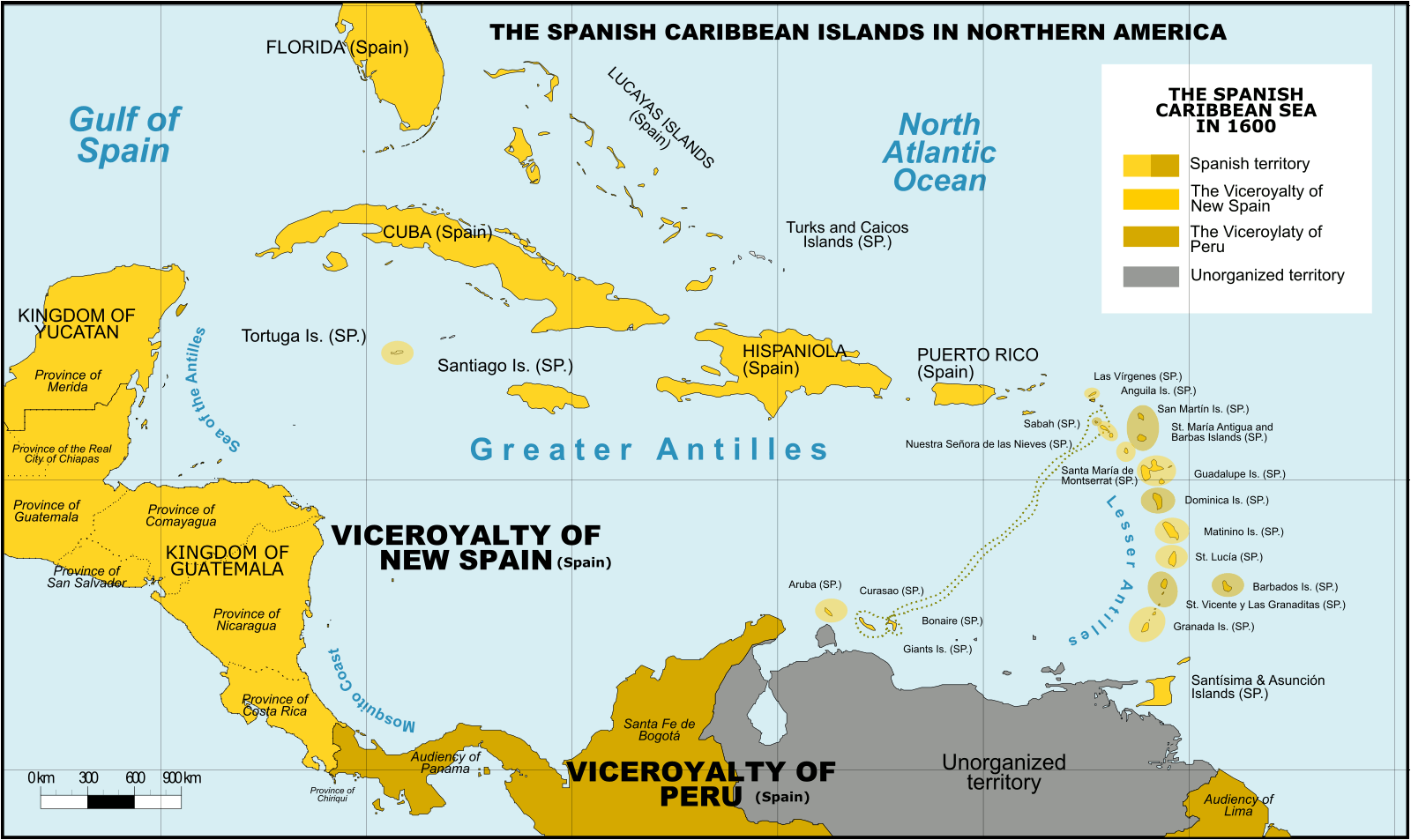
Spanish Caribbean Islands 1600 Spanish Overseas territories Northern America Turks and Caicos Islands (1492-1516, 1516-1678) * Islas Turcas y Caicos The Bahamas (1492-1516, 1516-1648) *Islas Lucayas Bermuda (1503-1516, 1516-1609) *Carabela/Isla de los Diablos Greater Antilles Cuba (1492-1762, 1763-1898) *Juana Cayman Islands (UK) (1503-1670) *Islas de las Tortugas La Española/Hispanola (1492-1795, 1801-1822) Dominican Republic (1492-1795, 1801-1822, 1861-1863) *Santo Domingo Haiti (1492-1793) *Santa María Jamaica (1492-1655) *Isla Santiago Puerto Rico (US) (1493-1898) *San Juan Bautista Lesser Antilles Leeward Islands: Virgin Islands (1493-1587) *Islas Once Mil Vírgenes / Islas Vírgenes St. Thomas (US) (1493-1587) St. John (US) (1493-1587) St. Croix (US) (1493-1587) Water Island (US) (1493-1587) British Virgin Islands (UK) (1493-1648) *Islas Once Mil Vírgenes / Islas Vírgenes Tortola (UK) (1493-1648) Virgin Gorda (UK) (1493-1672) Anegada (UK) (1493-1672) Jost Van Dyke (UK) (1493-1672) Anguilla (UK) (1500-1631, 1631-1650) *Isla de la Anguila Saint Martin/Sint Maarten (France/Neth.) (1493-1631) *San Martín Saint-Barthélemy (Fr.) (1493-1648) *San Bartolomeo Saba (Neth.) (1493-1640) *Saba/San Cristóbal Sint Eustatius (Neth.) (1493-1640) *San Eustaquio St. Kitts and Nevis (1493-1628) *Nuestra Señora de las Nieves Saint Kitts (1493-1628) *San Cristóbal Nevis (1493-1628) *Nieves Antigua and Barbuda Barbuda (1493-1628) *Santa Dulcina Antigua (1493-1632) *Santa María de la Antigua Redonda (1493-1632) *Santa María la Redonda Montserrat (UK) (1493-1632) *Santa María de Monstserrat Guadeloupe (Fr.) (1493-1631) *Santa Guadalupe Windward Islands: Dominica (1493-1635) *Domingo Martinique (Fr.) (1502-1635) *Martinino Saint Lucia (St. Lucia) (1502-1660) *Santa Lucía Barbados (1492-1620) *Los Barbados/El Barbudo St. Vincent and the Grenadines (1498-1627) *San Vicente Saint Vincent the Grenadines Grenada (1498-1650) *Concepción Carriacou & Petite Martinique (Grenada) Trinidad & Tobago (1498-1628) *Santísima e Asunción Aruba (Neth.) (1499-1648) *Aruba/Oroba Curaçao (Neth.) (1499-1634) *Curasao/Isla de los Gigantes Bonaire (Neth.) (1499-1635) * Bonaire/Buon Aire Viceroyalty of New Granada Los Roques Archipelago (Ven) La Orchila (Ven) La Tortuga (Ven) La Blanquilla (Ven) Margarita Island (Ven) Coche (Ven) Cubagua (Ven) Other islands (Ven) *Founded Spanish names
CARIBBEAN ISLANDS - WEST INDIES
The region, situated largely on the Caribbean Plate, has more than 700 islands, islets, reefs and cays (see the list of Caribbean islands). Three island arcs delineate the eastern and northern edges of the Caribbean Sea: The Greater Antilles to the north, and the Lesser Antilles and Leeward Antilles to the south and east. Together with the nearby Lucayan Archipelago, these island arcs make up the West Indies.
The Bahamas and the Turks and Caicos Islands are sometimes considered to be a part of the Caribbean, even though they are neither within the
Caribbean Sea nor on its border. However, The Bahamas is a full member state of the Caribbean Community and the Turks and Caicos Islands are an associate member. Belize, Guyana, and Suriname are also considered part of the Caribbean despite being mainland countries and they are full member states of the Caribbean Community and the Association of Caribbean States. Several regions of mainland North and South America are also often seen as part of the Caribbean because of their political and cultural ties with the region. These include Belize, the Caribbean region of Colombia, the Venezuelan Caribbean, Quintana Roo in Mexico (consisting of Cozumel and the Caribbean coast of the Yucatán Peninsula), and The Guianas (Guyana, Suriname, French Guiana, Guayana Region in Venezuela, and Amapá in Brazil).
The islands of the Caribbean (the West Indies) are often regarded as a subregion of North America, though sometimes they are included in Middle America or then left as a subregion of their own and are organized into 30 territories including sovereign states, overseas departments, and dependencies. From 15 December 1954, to 10 October 2010, there was a country known as the Netherlands Antilles composed of five states, all of which were Dutch dependencies. From 3 January 1958, to 31 May 1962, there was also a political union called the West Indies Federation composed of ten English-speaking Caribbean territories, all of which were then British dependencies.
These islands include active volcanoes, low-lying atolls, raised limestone islands, and large fragments of continental crust containing tall mountains and insular rivers. Each of the three archipelagos of the West Indies has a unique origin and geologic composition.
SARGASSUM:
Represents a present
threat to the economics of the Caribbean Islands, the Gulf of Mexico, and
African west coast, but is also a potential asset if it can be equitably harvested and used for:
BIOMASS - BUILDING
MATERIALS - CANCER
TREATMENTS - CLOTHING
& SHOES - CO2
SEQUESTRATION - COSMETICS
FERTILIZERS - FOODS - MEDICINES - MINERALS - PACKAGING - SUPPLEMENTS - VITAMINS
GREATER ANTILLES
The Greater Antilles is geologically the oldest of the three archipelagos and includes both the largest islands (Cuba, Jamaica, Hispaniola, and Puerto Rico) and the tallest mountains (Pico Duarte, Blue Mountain, Pic la Selle, Pico Turquino) in the Caribbean. The islands of the Greater Antilles are composed of strata of different geological ages including Precambrian fragmented remains of the North American Plate (older than 541 million years), Jurassic aged limestone (201.3-145 million years ago), as well as island arc deposits and oceanic crust from the Cretaceous (145-66 million years ago).
The Greater Antilles originated near the Isthmian region of present day Central America in the Late Cretaceous (commonly referred to as the Proto-Antilles), then drifted eastward arriving in their current location when colliding with the Bahama Platform of the North American Plate ca. 56 million years ago in the late Paleocene. This collision caused subduction and volcanism in the Proto-Antillean area and likely resulted in continental uplift of the Bahama Platform and changes in sea level. The Greater Antilles have continuously been exposed since the start of the Paleocene or at least since the Middle Eocene (66-40 million years ago), but which areas were above sea level throughout the history of the islands remains unresolved.
The oldest rocks in the Greater Antilles are located in Cuba. They consist of metamorphosed graywacke, argillite, tuff, mafic igneous extrusive flows, and carbonate rock. It is estimated that nearly 70% of Cuba consists of karst limestone. The Blue Mountains of Jamaica are a granite outcrop rising over 2,000 meters, while the rest of the island to the west consists mainly of karst limestone. Much of
Hispaniola, Puerto Rico, and the Virgin Islands were formed by the collision of the Caribbean Plate with the North American Plate and consist of 12 island arch terranes. These terranes consist of oceanic crust, volcanic and plutonic rock.
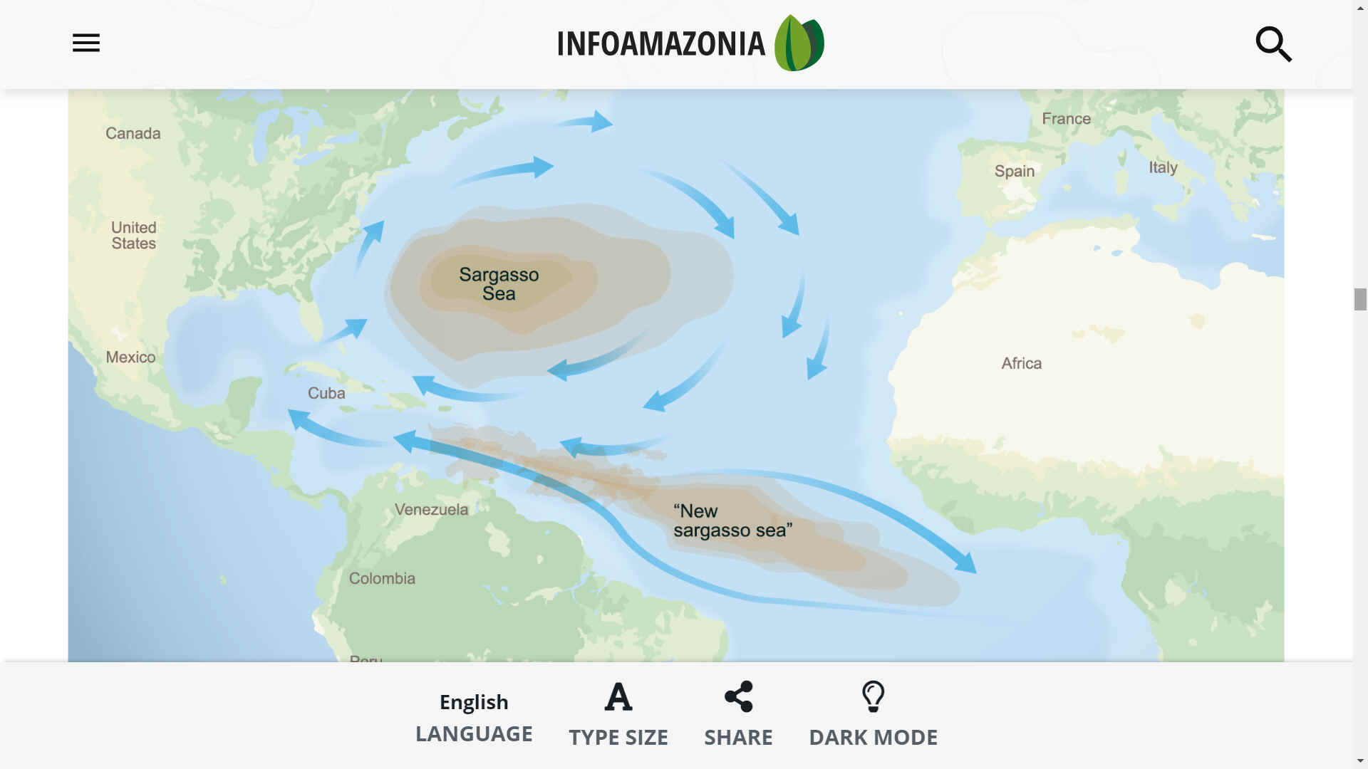
Map
of the North and South Atlantic
Oceans, showing the Sargasso Sea &
New
Sargasso Sea. The Cleaner
Ocean Foundation is concerned that as ocean
warming and acidification continues, with addition leaching of fertilizers
from
farmland, to support the growing human population (who will need food), that
sargassum migration could occur, seeding the pestilent macro algae in the Indian
and Pacific
oceans.
LESSER ANTILLES
The Lesser Antilles is a volcanic island arc rising along the leading edge of the
Caribbean Plate due to the subduction of the
Atlantic seafloor of the North American and South American plates. Major islands of the Lesser Antilles likely emerged less than 20 Ma, during the Miocene. The volcanic activity that formed these islands began in the Paleogene, after a period of volcanism in the Greater Antilles ended, and continues today. The main arc of the Lesser Antilles runs north from the coast of Venezuela to the Anegada Passage, a strait separating them from the Greater Antilles, and includes 19 active volcanoes.
The area has some
of the most interesting locations on Planet
Earth.
LUCAYAN ARCHIPELAGO
The Lucayan Archipelago includes The Bahamas and the Turks and Caicos Islands, a chain of barrier reefs and low islands atop the Bahama Platform. The Bahama Platform is a carbonate block formed of marine sediments and fixed to the North American Plate. The emergent islands of the Bahamas and Turks and Caicos likely formed from accumulated deposits of wind-blown sediments during Pleistocene glacial periods of lower sea level.
SARGASSUM
STATE OF EMERGENCY
During a talk at the University of West Indies, Edmund Bartlett, co-chair at the Global Tourism Resilience and Crisis Management Center, said that the annual cost of cleaning-up the Caribbean islands was around 120 million dollars.
Quintana Roo’s Government reported that in 2018 they removed 522,226 tons of sargassum from the public beaches and coastal zones, which represented an investment of 17 million dollars. For 2019 and 2020 there are no concise figures.
The mentioned amount of money is aside from what each hotel allocates to clean-up its beach-front every day, and this cost could be up to 60 thousand dollars annually for a medium size hotel, according to hotel owners.
In June of 2019, the first International convention to address the sargassum problem was held in Cancun,
Mexico. At this meeting, representatives from 13 Caribbean countries committed to working together through public policies and knowledge production to deal with this phenomenon. The commitment was endorsed in a second meeting held on the island of Guadalupe in October of the same year.
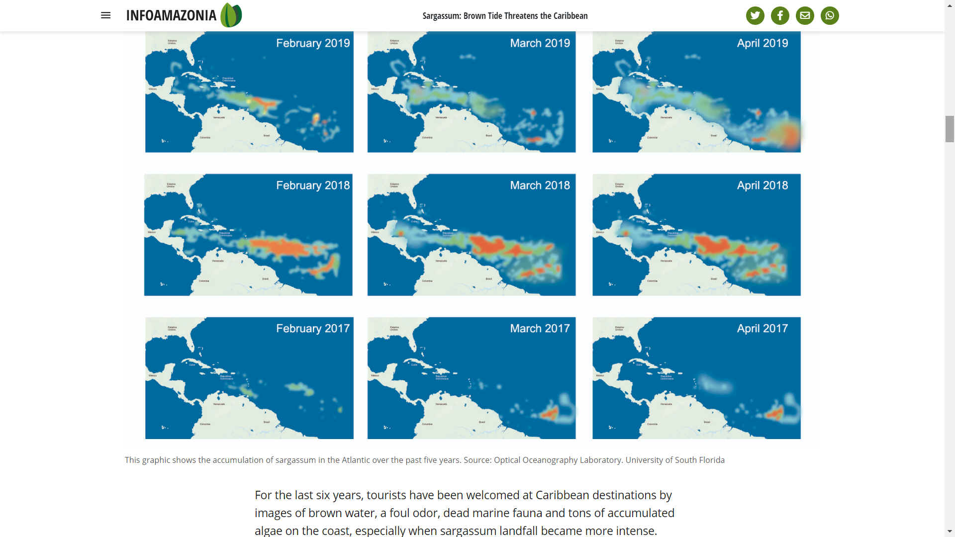
NEW SARGASSO SEA
It is a relatively new phenomenon of sargassum accumulation between the coasts of Brazil and
Africa, in the South Atlantic, which some have called “New
Sargasso
Sea.” Alfonso Aguirre Muñoz, former Director-General of the Group of Ecology and Conservation Islands, explains that the sargassum biomass originates along the eastern Atlantic coast of Africa and the mouth of the
Congo
River and is swept along by marine currents that circulate through tropical latitudes, passing across the mouth of the
Amazon River where it is fed by the increasing outflow of nutrients, along the northeastern coast of
Brazil, finally reaching the Caribbean Sea and continuing on to the coast of Florida through the
Gulf of
Mexico.
Caribbean waters are historically “oligotrophic”, meaning they typically have a very low nutrient load, hence its picturesque blue color and legendary transparency. But when the sargassum algae reach the coast, they completely transform ecosystems and landscape.
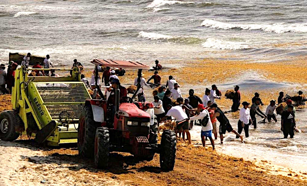
Since 2015, some Caribbean countries have taken measures to mitigate the effects of sargassum on the coasts. In Mexico, the Secretariat of Environment and Natural Resources (Semarnat, by its acronym in Spanish) issued a series of guidelines for the treatment of algae that turned into non-formal standards. For example, burying sargassum in the sand is prohibited – a recurring practice until 2018. There is a specific machinery allowed to collect sargassum, so it does not damage
sea turtles and algae must be taken to a proper waste disposal.
However, the coasts already show visible impacts.
Hydrogeologist Guadalupe Velazquez, from the Research Center for Sustainable Development (Cides, by its acronym in Spanish), indicates that in the town of Puerto Morelos in Quintana Roo, beaches have suffered from serious erosion and compaction, because in the process of removing algae, many kilos of sand are also taken away, in addition to the pressure caused by the continuous crossing of machinery.
The problems caused by the excessive landfall of sargassum do not end when it is taken off the beach, because to date only one municipality, Puerto Morelos, has set up a final disposal site with a geomembrane to avoid the pollution of soil by leachates. Other municipalities, in the best of cases, dispose of sites specifically set up for this type of organic waste, located far from urban zones.
Alejandro López Tamayo, president of the Centinelas del Agua (Water Sentinels) organization, explains that the Yucatan Peninsula region in Mexico has a system of porous karstic ground, with an aquifer a few meters deep. Without appropriate processing, the leachates released during the rotting of sargassum rotting easily seep into the
water table and the aquifer, polluting the soil and
water.
MEXICO'S MANAGEMENT TO DEAL WITH SARGASSUM
For five years, Mexican government has failed to contain or reduce the problem. During the first years, Quintana Roo’s government, municipalities, and hotels were in charge of the beach cleaning work. That entailed investments of many millions of pesos to build barriers, purchase machinery, pay workers and transport and dispose of the waste.
In 2019, the Quintana Roo´s Government Advisory Council to manage sargassum was created, and in conjunction with members of the scientific community and business owners, several initiatives for the integrated management of sargassum were started, from monitoring and collection at sea, on the beaches, to final disposal and even industrialization (turning the waste into useful by-products). The proposed projects would be funded with a joint contribution of the three levels of Government.
However, because of some conflicts among the stakeholders and the outrage arising from suspected interference from an official in the drafting of contracts — whose connection to the alleged scandal was not verified — the main project nicknamed “Caribbean Shield” was discarded.
Manuel López Obrador, Mexico’s President, ordered the Secretariat to take charge of the issue, which he said he “inherited from other governments” and which he claimed was “amplified” to criticize his governance.
After the announced decision in June of 2019, the Secretariat of the Navy (Semar, by its acronym in Spanish), took the lead in coordinating strategy with Quintana Roo’s Secretariat of Ecology and Environment (SEMA, by its acronym in Spanish) and the municipalities along the coastline.
One of the first strategies implemented by the Semar was the collection of sargassum in the open sea, following up on the Advisory Council’s recommendations. Five deep draft vessels were assigned to carry out this task.
Nevertheless, the support from the federal agency is minimal and comes with high operational costs. From 2019 to September 2020, the Semar reported collecting 304 tons of sargassum in the sea, barely 1.6 percent of the 18,317 tons collected on public beaches by municipal city councils in Quintana Roo.
Sargassum represents a threat to the Mexican Caribbean tourism industry, the most powerful in Latin America. “If a prompt solution to the problem is not sought, consequences for the future could be fateful,” warns Rodríguez Martínez.
Quinta Roo receives 14 million visitors annually, with a contribution to the national Gross Domestic Product of more than 60 billion pesos, according to reports from the Tourism Secretariat (Sectur, by its acronym in Spanish).
In order to lead the Latin American tourist market, destinations such as Cancun, Playa del Carmen, Tulum and Cozumel offer the beauty of their beaches as the main attraction.
In beaches with high sargassum concentrations, especially in the bays and reef lagoons where the algae become stagnant, the color of the water has changed from turquoise to brown, completely changing the landscape even when is not the sargassum season. Examples of this phenomenon can be found on the coasts of Puerto Morelos and Xcalak, as well as the bays of Sian Ka’an. In addition to the environmental problems that this represents, brown waters, like a polluted river, are not attractive to national and foreign tourists.
SOLUTIONS STILL UNCERTAIN
Currently, there are several proposals to harvest and process the sargassum in the Caribbean, a measure that would solve part of the problem by transforming the algae into a resource with commercial value, according to promoters.
One of the most advanced projects is from the company Dianco Mexico, which will start operations in Cancun in mid April to transform sargassum into biofertilizer. Another product they plan to produce is cellulose.
Héctor Romero, the company’s CEO , affirms that the factory will have the capacity to process up to 600 tons of algae.
Other proposals suggest the algae can be used in the livestock feed industry, in the cosmetic industry and to generate biofuel.
To Adán Caballero, the research available to date on the algae of the New Sargasso Sea is not enough to establish its potential use, because the contaminants it contains could represent a risk to public health.
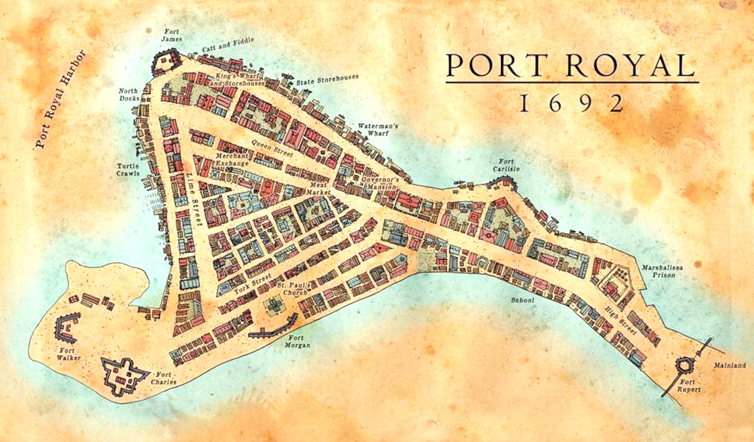
Map
of Port Royal and Kingston, where the notorious buccaneer, Sir Henry Morgan
was buried.
CITIES
LOST IN INNERSPACE
ATLANTIS
- MEDITERRANEAN SEA
ATLIT-YAM
- ISRAEL
BAIA
- ITALY
DWARKA
- INDIA
PAVLOPETRI
- GREECE
PHANAGORIA
- BLACK SEA
PORT
ROYAL - JAMAICA
RUNGHOLT
- DENMARK
THONIS-HERACLEION
AND ALEXANDRIA - EGYPT
YONAGUNI
JIMA - JAPAN
STUDIO/AGENTS: A draft script for
Kulo-Luna is available on request. Cleopatra The Mummy is currently under
development
|