....
In
common with all larger ships and aircraft, in this work of
fiction John
Storm ocean adventure, relies on a whole array of
instruments aboard the Elizabeth
Swann, such as LIDAR, RADAR and SONAR, to detect and
avoid other vessels, to be able to comply with COLREGs,
Collision
At Sea Regulations, especially when the Swann is
operating in autonomous
navigation mode, with Captain
Nemo at the helm.
RADAR
Radar is a radiolocation system that uses radio waves to determine the distance (ranging), angle (azimuth), and radial velocity of objects relative to the site. It is used to detect and track aircraft, ships, spacecraft, guided missiles, and motor vehicles, and map weather formations, and terrain. A radar system consists of a transmitter producing electromagnetic waves in the radio or microwaves domain, a transmitting antenna, a receiving antenna (often the same antenna is used for transmitting and receiving) and a receiver and processor to determine properties of the objects. Radio waves (pulsed or continuous) from the transmitter reflect off the objects and return to the receiver, giving information about the objects' locations and speeds.
Radar was developed secretly for military use by several countries in the period before and during
World War
II. A key development was the cavity magnetron in the United Kingdom, which allowed the creation of relatively small systems with sub-meter resolution. The term RADAR was coined in 1940 by the United States Navy as an acronym for radio detection and ranging. The term radar has since entered English and other languages as a common noun, losing all capitalization.
The modern uses of radar are highly diverse, including air and terrestrial traffic control, radar astronomy, air-defense systems, anti-missile systems, marine radars to locate landmarks and other ships, aircraft anti-collision systems, ocean surveillance systems, outer space surveillance and rendezvous systems, meteorological precipitation monitoring, altimetry and flight control systems, guided missile target locating systems, self-driving cars, and ground-penetrating radar for geological observations. Modern high tech radar systems use digital signal processing and machine learning and are capable of extracting useful information from very high noise levels.
Other systems similar to radar make use of other parts of the electromagnetic spectrum. One example is lidar, which uses predominantly infrared light from lasers rather than radio waves. With the emergence of driver-less vehicles, radar is expected to assist the automated platform to monitor its environment, thus preventing unwanted incidents.
LIDAR
Lidar is an acronym of "light detection and ranging" or "laser imaging, detection, and ranging". It is a method for determining ranges by targeting an object or a surface with a laser and measuring the time for the reflected light to return to the receiver. It is sometimes called 3-D laser scanning, a special combination of 3-D scanning and laser scanning. LIDAR has terrestrial, airborne, and mobile applications.
Lidar is commonly used to make high-resolution maps, with applications in surveying, geodesy, geomatics, archaeology, geography, geology, geomorphology, seismology, forestry, atmospheric physics, laser guidance, airborne laser swath mapping (ALSM), and laser altimetry. It is used to make digital 3-D representations of areas on the Earth's surface and ocean bottom of the intertidal and near coastal zone by varying the wavelength of light. It has also been increasingly used in control and navigation for autonomous cars and for the helicopter Ingenuity on its record-setting flights over the terrain of Mars.
NOAA
Lidar, which stands for Light Detection and Ranging, is a remote sensing method that uses light in the form of a pulsed laser to measure ranges (variable distances) to the Earth. These light pulses—combined with other data recorded by the airborne system — generate precise, three-dimensional information about the shape of the Earth and its surface characteristics.
A lidar instrument principally consists of a laser, a scanner, and a specialized GPS receiver. Airplanes and helicopters are the most commonly used platforms for acquiring lidar data over broad areas. Two types of lidar are topographic and bathymetric. Topographic lidar typically uses a near-infrared laser to map the land, while bathymetric lidar uses water-penetrating green light to also measure seafloor and riverbed elevations.
Lidar systems allow scientists and mapping professionals to examine both natural and manmade environments with accuracy, precision, and flexibility.
NOAA scientists are using lidar to produce more accurate shoreline maps, make digital elevation models for use in geographic information systems, to assist in emergency response operations, and in many other applications.
HOW IS LIDAR DATA COLLECTED?
When an airborne laser is pointed at a targeted area on the ground, the beam of light is reflected by the surface it encounters. A sensor records this reflected light to measure a range. When laser ranges are combined with position and orientation data generated from integrated GPS and Inertial Measurement Unit systems, scan angles, and calibration data, the result is a dense, detail-rich group of elevation points, called a "point cloud."
Each point in the point cloud has three-dimensional spatial coordinates (latitude, longitude, and height) that correspond to a particular point on the Earth's surface from which a laser pulse was reflected. The point clouds are used to generate other geospatial products, such as digital elevation models, canopy models, building models, and contours.
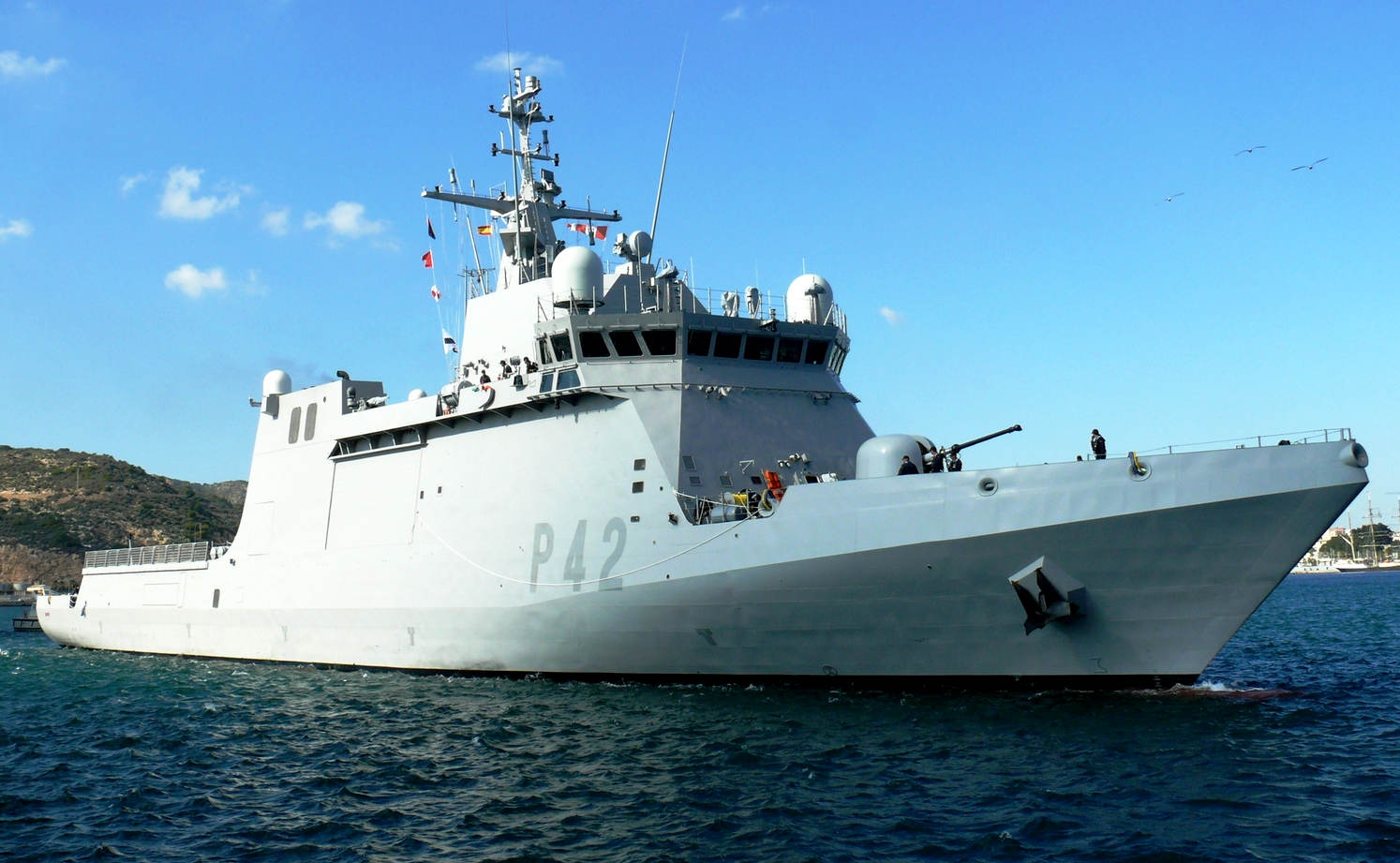
The
Meteoro-class offshore patrol vessel, also known as Buque de Acción Marítima (BAM), are new modular offshore patrol vessels of the Spanish Navy adapted to different purposes from a common base, manufactured by
Navantia, bristling with radar domes.
AUTONOMOUS VEHICLES
Autonomous vehicles may use lidar for obstacle detection and avoidance to navigate safely through environments. The introduction of lidar was a pivotal occurrence that was the key enabler behind Stanley, the first autonomous vehicle to successfully complete the
DARPA Grand Challenge. Point cloud output from the lidar sensor provides the necessary data for robot software to determine where potential obstacles exist in the environment and where the robot is in relation to those potential obstacles. Singapore's Singapore-MIT Alliance for Research and Technology (SMART) is actively developing technologies for autonomous lidar vehicles.
The very first generations of automotive adaptive cruise control systems used only lidar sensors.
Object detection for transportation systems
In transportation systems, to ensure vehicle and passenger safety and to develop electronic systems that deliver driver assistance, understanding vehicle and its surrounding environment is essential. Lidar systems play an important role in the safety of transportation systems. Many electronic systems which add to the driver assistance and vehicle safety such as Adaptive Cruise Control (ACC), Emergency Brake Assist, and Anti-lock Braking System (ABS) depend on the detection of a vehicle's environment to act autonomously or semi-autonomously. Lidar mapping and estimation achieve this.
Basics overview: Current lidar systems use rotating hexagonal mirrors which split the laser beam. The upper three beams are used for vehicle and obstacles ahead and the lower beams are used to detect lane markings and road features.[91] The major advantage of using lidar is that the spatial structure is obtained and this data can be fused with other sensors such as radar, etc. to get a better picture of the vehicle environment in terms of static and dynamic properties of the objects present in the environment. Conversely, a significant issue with lidar is the difficulty in reconstructing point cloud data in poor weather conditions. In heavy rain, for example, the light pulses emitted from the lidar system are partially reflected off of rain droplets which adds noise to the data, called 'echoes'.
Below mentioned are various approaches of processing lidar data and using it along with data from other sensors through sensor fusion to detect the vehicle environment conditions.
OBSTACLE DETECTION AND ROAD ENVIRONMENT RECOGNITION USING LIDAR
This method proposed by Kun Zhou et al. not only focuses on object detection and tracking but also recognizes lane marking and road features. As mentioned earlier the lidar systems use rotating hexagonal mirrors that split the laser beam into six beams. The upper three layers are used to detect the forward objects such as vehicles and roadside objects. The sensor is made of weather-resistant material. The data detected by lidar are clustered to several segments and tracked by Kalman filter. Data clustering here is done based on characteristics of each segment based on object model, which distinguish different objects such as vehicles, signboards, etc. These characteristics include the dimensions of the object, etc. The reflectors on the rear edges of vehicles are used to differentiate vehicles from other objects. Object tracking is done using a two-stage Kalman filter considering the stability of tracking and the accelerated motion of objects Lidar reflective intensity data is also used for curb detection by making use of robust regression to deal with occlusions. The road marking is detected using a modified Otsu method by distinguishing rough and shiny surfaces.
ADVANTAGES
Roadside reflectors that indicate lane border are sometimes hidden due to various reasons. Therefore, other information is needed to recognize the road border. The lidar used in this method can measure the reflectivity from the object. Hence, with this data road border can also be recognized. Also, the usage of sensor with weather-robust head helps detecting the objects even in bad weather conditions. Canopy Height Model before and after flood is a good example. Lidar can detect high detailed canopy height data as well as its road border.
Lidar measurements help identify the spatial structure of the obstacle. This helps distinguish objects based on size and estimate the impact of driving over it.
Lidar systems provide better range and a large field of view which helps detecting obstacles on the curves. This is one major advantage over RADAR systems which have a narrower field of view. The fusion of lidar measurement with different sensors makes the system robust and useful in real-time applications, since lidar dependent systems can't estimate the dynamic information about the detected object.
It has been shown that lidar can be manipulated, such that self-driving cars are tricked into taking evasive action.
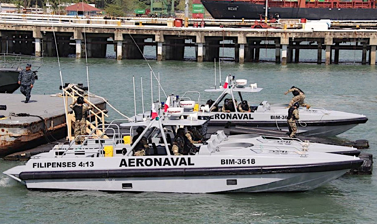
The National Air and Naval Service of Panama
operate several Damen Interceptors, as seen above, equipped
with Raymarine radar sets, that are used to identify and
track potential law breakers. Also useful in rescue
operations, when boats may have got lost or capsized.