One significant part of the environment that wreaked havoc on
colonists was natural disasters, such as earthquakes and hurricanes, the
likes of which they had no experience of.
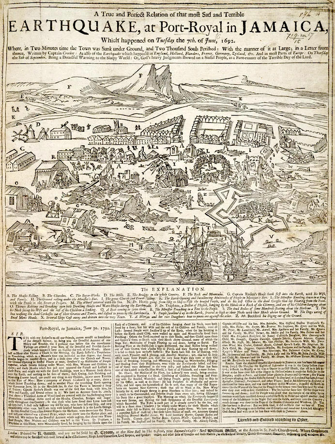
An
earthquake in the Caribbean
struck Port Royal, Jamaica, on
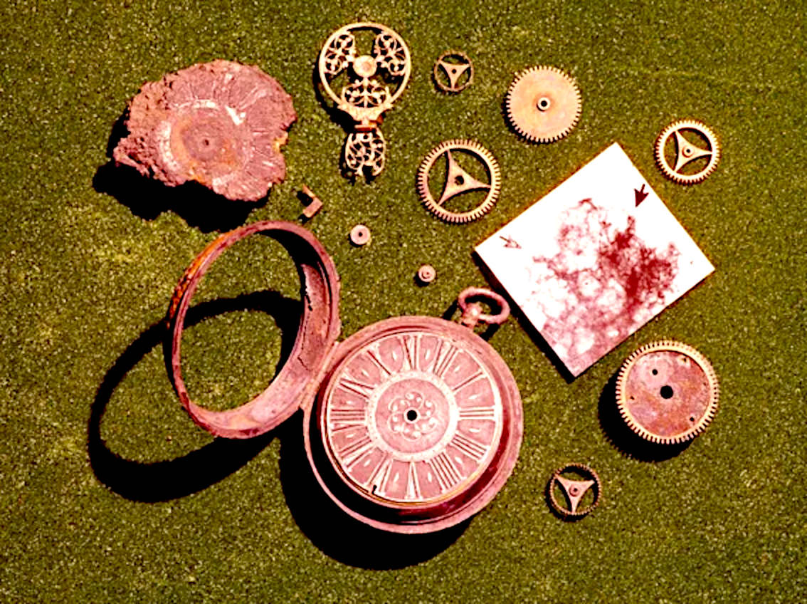
the 7th of June 1692. A stopped pocket watch found in the harbor during a 1959 excavation
conducted by Edwin
Link and his wife Marion, indicated that the resultant tsunami occurred around 11:43 AM local time.
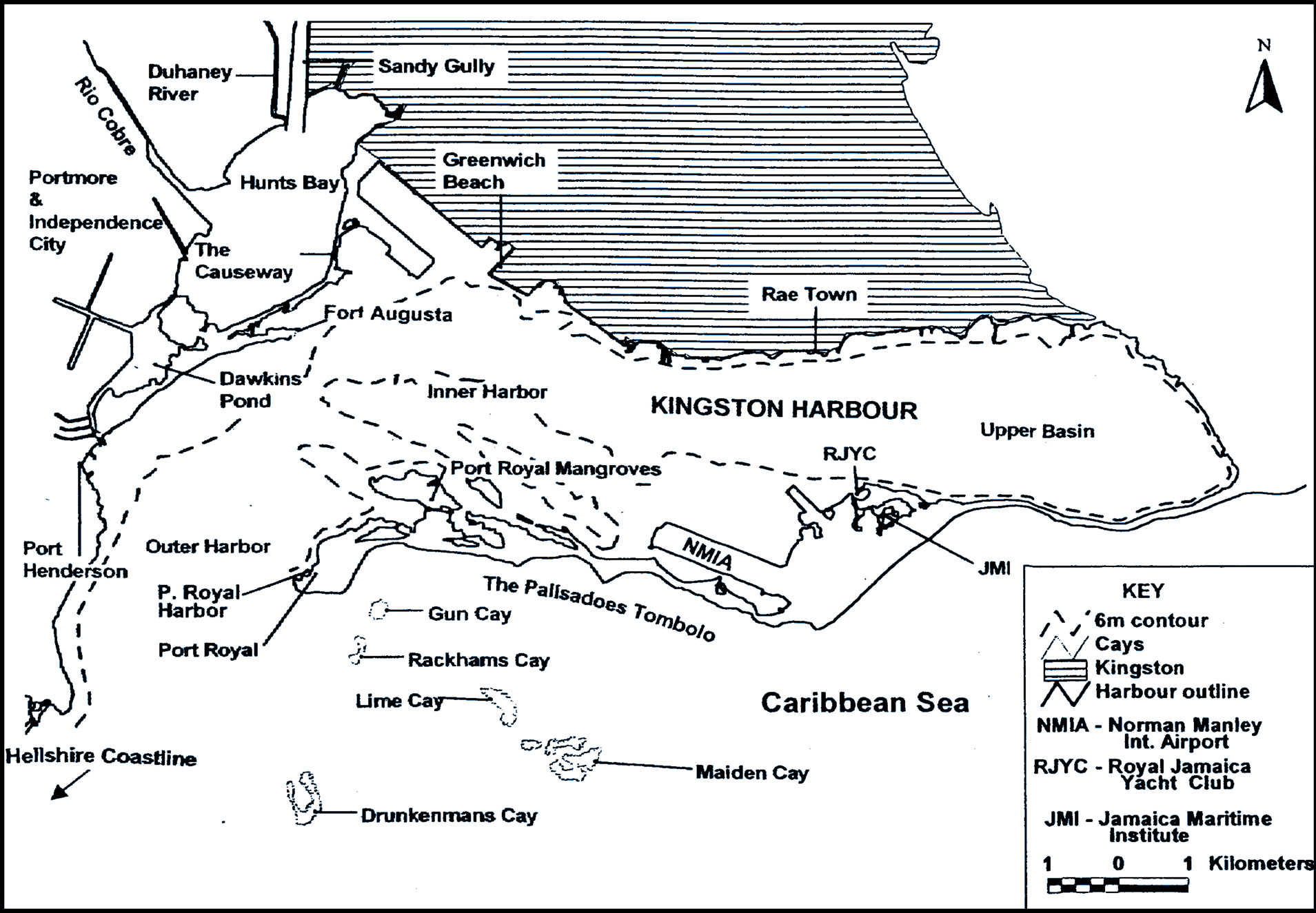
Known as the "storehouse and treasury of the West Indies" and as "one of the wickedest places on Earth", Port Royal was, at the time, the unofficial capital of Jamaica and one of the busiest and wealthiest ports in the Americas, as well as a common home port for many of the
privateers and pirates operating on the
Caribbean
Sea.
The 1692 earthquake caused most of the city to sink below sea level. About 2,000 people died as a result of the earthquake and the following tsunami, and another 3,000 people died in the following days due to injuries and disease.
The town of Port
Royal is situated next to a natural deep water harbor. It became the busiest port in English America, which is
evidenced by the records of port traffic.
In 1688, 213 ships entered Port Royal‟s harbor, whereas only 102 ships were
recorded at Barbados. Comparatively, all of New England‟s ports totaled 226 ships for
the year.2 Not only were maritime shipping statistics high, but Port Royal‟s population
was second only to Boston in the late seventeenth-century, with pre-earthquake
population estimates at approximately 6,500 residents with 2,500 being
slaves. In 1683, Francis Hanson, a visitor to the island noted that “there is more plenty of
running Cash Proportionally to the number of its Inhabitants than is in
London.” This great amount of cash flowed through the streets of Port Royal because of the illicit
activities of buccaneers, who used the port as their operating base. The buccaneers
continually raided Spanish ships and strongholds throughout the Caribbean, and the
captured booty significantly increased Port Royal‟s wealth, which also contributed to the
raucous atmosphere of the harbor town.
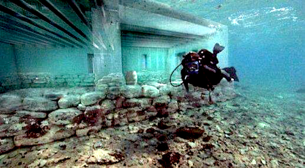
A
diver using SCUBA gear to explore Port Royal
TECTONIC SETTING
The island of Jamaica lies on the boundary between the Caribbean Plate and the Gonâve Microplate. The Gonâve microplate is a 1,100 km (680 mi) long strip of mainly oceanic crust formed by the Cayman spreading ridge within a strike-slip pull-apart basin on the northern transform margin of the
Caribbean Plate with the North American Plate.Two-thirds of the town, about 13 ha (33 acres), sank into the sea immediately after the main shock. According to Robert Renny in his An History of Jamaica (1807): "All the wharves sunk at once, and in the space of two minutes, nine-tenths of the city were covered with water, which was raised to such a height, that it entered the uppermost rooms of the few houses which were left standing. The tops of the highest houses were visible in the water and surrounded by the masts of vessels, which had been sunk along with them."
Before the earthquake the town consisted of 6,500 inhabitants living in about 2,000 buildings, many constructed of brick and with more than one storey, and all built on loose sand. During the shaking, the sand liquefied and the buildings, along with their occupants, appeared to flow into the sea. More than twenty ships moored in the harbour were capsized. One ship, the frigate Swann, was carried over the rooftops by the tsunami. During the main shock, the sand was said to have formed waves. Fissures repeatedly opened and closed, crushing many people. After the shaking stopped the sand again solidified, trapping many victims. Palisadoes cemetery, where the grave of the former pirate
Sir Henry Morgan was located, was one of the parts of the city to fall into the sea; his body has never been found.
At Liguanea (present-day Kingston), all the houses were destroyed and water was ejected from 12 m (40 foot) deep wells. Almost all the houses at St. Jago (Spanish Town) were destroyed.
Many landslides occurred across the island. The largest, the Judgement Cliff landslide, displaced the land surface by up to 800 m and killed 19 people. Several rivers were temporarily dammed and a few days after the earthquakes the harbour became flooded with large numbers of trees stripped of their bark brought down after one of these dams was breached.
A pocket watch, made in the Netherlands by the French maker Blondel in about 1686, was recovered during underwater archaeological investigations led by Edwin Link in 1959. The watch was stopped with its hands pointing to 11:43 AM; this matches well with contemporary accounts of the timing of the earthquake. Jamaica was formed by uplift associated with a restraining bend along this strike-slip structure. The focal mechanisms of earthquakes around Jamaica are primarily sinistral strike-slip along WSW-ENE trending faults and minor reverse or thrust motion on NW-SE trending faults. The 1692 event is thought to have occurred on one of these strike-slip faults.
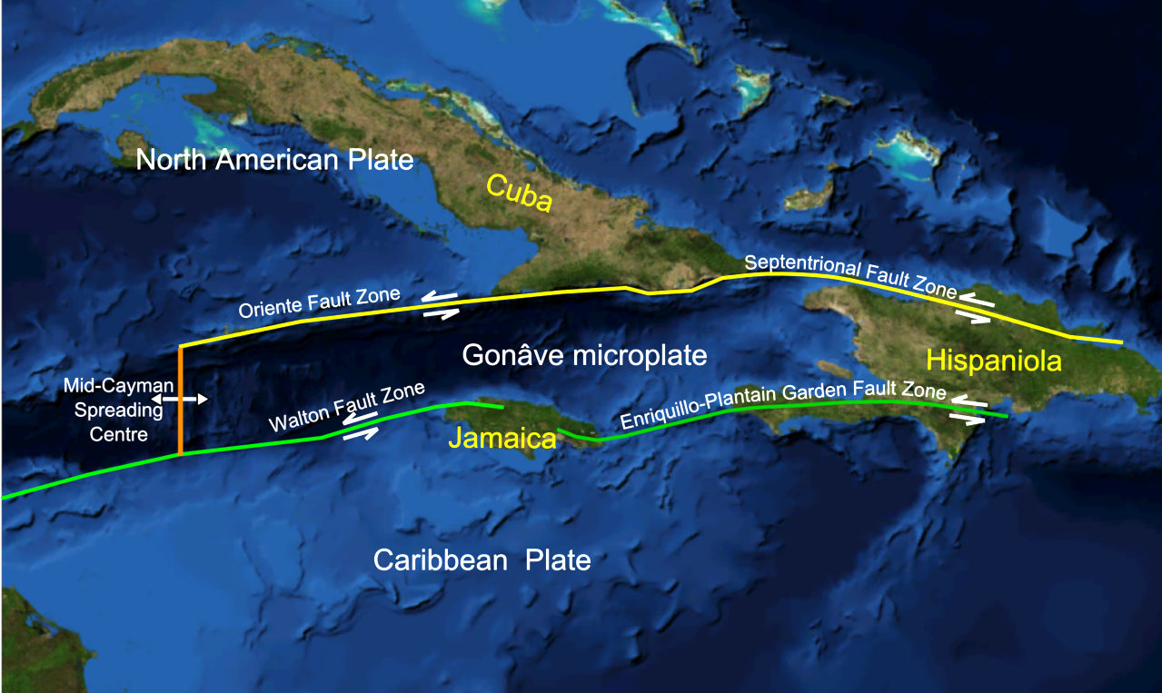
The Gonâve
microplate, showing the main fault zones that bound it.
DAMAGE
Two-thirds of the town, about 13 ha (33 acres), sank into the sea immediately after the main shock. According to Robert Renny in his An History of Jamaica (1807): "All the wharves sunk at once, and in the space of two minutes, nine-tenths of the city were covered with water, which was raised to such a height, that it entered the uppermost rooms of the few houses which were left standing. The tops of the highest houses were visible in the water and surrounded by the masts of vessels, which had been sunk along with them."
Before the earthquake the town consisted of 6,500 inhabitants living in about 2,000 buildings, many constructed of brick and with more than one storey, and all built on loose sand. During the shaking, the sand liquefied and the buildings, along with their occupants, appeared to flow into the sea. More than twenty ships moored in the harbour were capsized. One ship, the frigate Swann, was carried over the rooftops by the tsunami. During the main shock, the sand was said to have formed waves. Fissures repeatedly opened and closed, crushing many people. After the shaking stopped the sand again solidified, trapping many victims. Palisadoes cemetery, where the grave of the former pirate Sir Henry Morgan was located, was one of the parts of the city to fall into the sea; his body has never been found.
At Liguanea (present-day Kingston), all the houses were destroyed and water was ejected from 12 m (40 foot) deep wells. Almost all the houses at St. Jago (Spanish Town) were destroyed.
Many landslides occurred across the island. The largest, the Judgement Cliff landslide, displaced the land surface by up to 800 m and killed 19 people. Several rivers were temporarily dammed and a few days after the earthquakes the harbour became flooded with large numbers of trees stripped of their bark brought down after one of these dams was breached.
A pocket watch, made in the Netherlands by the French maker Blondel in about 1686, was recovered during underwater archaeological investigations led by Edwin Link in 1959. The watch was stopped with its hands pointing to 11:43 AM; this matches well with contemporary accounts of the timing of the earthquake.
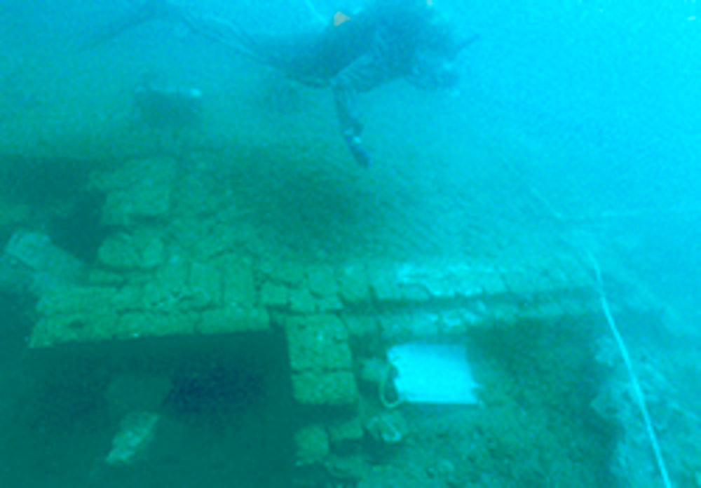
Visibility
is typically very poor. On this dive, the water was relatively clear,
good news for the team surveying the site.
AFTERMATH
Even before the destruction was complete, some of the survivors began looting, breaking into homes and warehouses. The dead were also robbed and stripped, and, in some cases, had fingers cut off to remove the rings that they wore.
In the immediate aftermath of the earthquake, it was common to ascribe the destruction to divine retribution on the people of Port Royal for their sinful ways. Members of the Jamaica Council declared: "We are become by this an instance of God Almighty's severe judgement." This view of the disaster was not confined to Jamaica; in Boston, the Reverend Cotton Mather said in a letter to his uncle: "Behold, an accident speaking to all our English America".
After the earthquake, the town was partially rebuilt. But the colonial government was relocated to Spanish Town, which had been the capital under Spanish rule. Port Royal was devastated by a fire in 1703 and a hurricane in 1722. Most of the sea trade moved to Kingston. By the late 18th century,
Port Royal was largely abandoned.
HOW
THE EARTHQUAKE AFFECTED FORWARD ARCHITECTURE & BUILDING DESIGN
The shock created by the 1692 earthquake jolted the heavy brick and stone structures in Port Royal to their foundations because the rigid building materials did not allow for any shock resistance.
That is why in Japan, traditional houses features paper walls and timber
construction.
Scientists propose that at the time of the earthquake, a process known as “liquefaction”
occurred beneath Port Royal. Liquefaction occurred when the water rushed underneath
the foundation of the town turning the individual particles of sand into a liquefied state resembling quicksand. In turn, the watery sand could not support the tall, heavy
buildings and the most affected structures sank into the harbor. The process of
liquefaction is evident by the results of earthquake damage which caused Forts James and
Carlisle along with Thames, Queen, and High streets to slide into the
sea. These results indicate that the earthquake did not simply shake the brick and stone structures so as to shift their foundations and eventually topple to the ground, but rather moved the sandy foundations downward, so that many of the buildings situated on the streets closest to the ocean were submerged intact with their upper stories remaining above water.
After the destruction of Port Royal, the English were faced with the dilemma of
what types of structures to build in place of the ones that failed to survive the shocks of the earthquake. Colonists had the choice to re-build in the popular English style
characterized by multi-story buildings constructed with heavy building materials or to re-evaluate their previous methods to better suit their new environmental circumstances. An eyewitness to the disaster noted that the low lying buildings constructed of
timber were among some of the only structures surviving after the earthquake.
Homes
that float and are (simply) flexibly tethered, constructed of wood,
are now installed in some flood prone areas. Thus in the case of Acts
of God, or Divine Intervention, they would not sink, or crumble, but
float and move.
Quaker John Pike similarly observed that the earthquake “hath not left a house standing in the whole place that was built of either stone or brick, nor anything that was built with the same materials” and that colonists “now think a Negro‟s house that is daubed with mortar and thatched... a pleasant house.”
Although Kingston existed across the harbor, Port Royal was rebuilt after the
earthquake with wooden buildings which could withstand an earthquake, but these
structures were defenseless against fire. In those times they did not
have fire retardant treatments for timber.
On January 9, 1703, fire destroyed all the
structures in Port Royal except for one building and two fortifications. Port Royal was
rebuilt again after the fire, and according to contemporary Francis Rogers, many of the
houses were rebuilt with brick but none were more than two stories high and were fitted
with large windows for “coolness.”
This observation reveals that colonists adapted
their structures to the various natural calamities in which they faced. The second
rebuilding of Port Royal exemplifies the tension labeled by Jack Greene as “inheritance”
versus “experience.” In summation, after the earthquake, colonists realized that the
multi-storied brick buildings were not practical and rebuilt with mostly wooden
structures; however, after the 1703 fire destroyed Port Royal again, colonists reverted
back to their brick structures with modifications to windows and restrictions on building height.
Colonists inherited their construction methods and their desire to use materials such as brick because this embodied the English culture. Colonists‟ reversion to less
flammable brick after the fire illustrates further adaptation of their building styles to better suit their foreign environment.
During the process of learning to survive in the tropics, the English colonists
gradually employed many of the time-tested Spanish building techniques, after observing
their ability to withstand Jamaica‟s natural environment first-hand.
Where at first they scorned such designs.
CHARACTERISTICS
Earthquake
There were three separate shocks, each with increasing intensity, culminating in the mainshock. The estimated size of the event was 7.5 on the moment magnitude scale.
Despite reports of the town flowing into the sea, the main result of the earthquake was subsidence caused by liquefaction. This would also explain an eyewitness account of houses being swallowed and people being buried up to their necks in the sand. The probable triggering of the Judgement Cliff landslide during the earthquake occurred along the line of the Plantain Garden fault. Movement on this structure has been suggested as the cause of the earthquake.
Landslides
The Judgement Cliff landslide is a complex rock-slide slump with a volume of about 131–181 × 106 m3. The slip surface is found within zones of clay and shale with gypsum at the base of a limestone unit. This landslide occurred after the earthquake but it remains possible that heavy rain over the few days after the event, or possibly during a hurricane in October later that year was the final trigger for the slip.
Tsunami
The sea was observed to retreat by about 300 yd (270 m) at Liguanea (probably near Kingston) while at Yallahs it withdrew 1 mi (1.6 km). It returned as a 6 ft (1.8 m) high wave that swept over the land. One possible cause of the tsunami is thought to be the slump and grain flow into the harbour from beneath the town itself, although the waves in the harbour may be better described as seiches and larger waves reported elsewhere, such as at Saint Ann's Bay, are explained as the result of an entirely separate submarine landslide, also triggered by the earthquake.
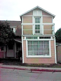
Examples
of aseismic creep. The house on the left was demolished. The stone
markers are a simulation to illustrate movement, where it is so gradual,
it is hardly noticeable.
FUTURE SEISMIC HAZARD
Estimates of current deformation of Jamaica suggest that sufficient strain has accumulated to generate a M=7.0–7.3 earthquake, similar in size to the 1692 event. This may mean that a repeat of this event is imminent, although this estimate relies on many assumptions, such as that none of the motion on the Plantain Garden fault is accommodated by aseismic creep.
ASEISMIC CREEP
In geology, aseismic creep or fault creep is measurable surface displacement along a fault in the absence of notable earthquakes. Aseismic creep may also occur as "after-slip" days to years after an earthquake. Notable examples of aseismic slip include faults in California (e.g. Calaveras Fault, Hayward Fault, and San Andreas Fault).
CAUSES
Aseismic creep accommodates far-field motions on localized zones of deformation at tectonic plate boundaries. The underlying causes of aseismic creep are primarily attributed to poor frictional strength of the fault, low normal stress acting on the fault in the shallow crust, and excessive pore-fluid pressures, which limit the viable amount of normal stress on a fault. The frictional reaction of geologic materials can explain the transition from seismic to aseismic deformation with depth. Friction along faults can cause sudden slips with associated stress drops (earthquakes), along with phases of no motion as stress recharges.
MEASUREMENTS
Knowing how creep rates vary temporally and spatially along faults has important implications for predicting the timing, locations, and potential sizes of future earthquakes as well as the mechanics of fault behavior. Measurements of inter-seismic strain, as well as the associated pattern of coupling, are also crucial because they reveal the pockets where stress is building up and may be released in future seismic ruptures. The emergence of space-based geodesy and newly developed remote sensing techniques are used to monitor crustal deformation in order to track aseismic creep on a fault. Theodolite surveys are used with alignment arrays to track the creep. These data may then be used to restrict a fault's seismic capacity.
EXAMPLES
Aseismic creep exists along the Calaveras Fault in Hollister, California. Streets crossing the fault in Hollister show significant offset. Several houses sitting atop the fault are notably twisted, yet still habitable. The city attracts geologists and geology students almost weekly.
Other examples of faults that have experienced aseismic creep include the San Andreas Fault in California and the North Anatolian Fault in Turkey. Creep along the Maacama Fault is about 8 mm per year, consistent with the steady movement along the rest of the Hayward Fault system.
EYE
WITNESS ACCOUNT
Dr. Emmanuel Heath
was a rector for the Anglican Church ministering at Port Royal, Jamaica,
on the fateful day when earthquakes and a subsequent tsunami, subsumed
the city in around twenty or so minutes.
He
described the dreadful
Earthquake, that
happened at Port Royal in Jamaica, on June the 7th, 1692; in two lengthy
letters to a friend. In 2022, the underwater
city is on a tentative list for inclusion as a UNESCO
World Heritage Site.
Captain
Sir Henry Morgan was a pirate, and privateer, ending up as the Governor of
Jamaica. He was buried at Palisadoes
Cemetery, then Port Royal was washed
into the Caribbean Sea, the result of an earthquake and
tsunami in 1692. Not to be
seen again for 300 years.
UNDERWATER
ARCHAEOLOGY EXCAVATION IN PORT ROYAL
Underwater explorations and excavations have been conducted in Port Royal over the years. Here is a listing of such excavations. After the 1692 earthquake, people tried to salvage anything considered to be valuable from the area, which became known as the Sunken City.
1859: Jeremiah Murphy a naval diver, using a diving bell located the remains of Fort James.
1956 - 1959: Edwin Link dug test pits in the King's Warehouse and Fort James.
1960:
Norman Scott explored Fort Carlisle.
1965 - 1968: Robert Marx excavated between twenty to thirty buildings in the Sunken City.
1969
- 1970: Philip Mayes Excavation. Mayes was hired by the Jamaican National Trust Commission to continue research. Mayes is accredited with uncovering
St. Paul’s Church of Port Royal, the largest building of the 17th century city.
1981 - 1990: Institute of Nautical Archaeology of the Texas A&M
(Agricultural & Mechanical) University in close cooperation with the Archaeology Division excavated buildings near the intersection of Queen and High Street.
Port Royal mangroves: Hurricane Refuge lagoon, Fort Rocky lagoon and Cemetery lagoon